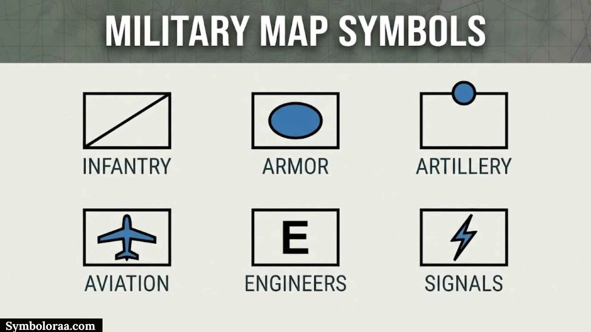
Military map symbols are a visual language used to show military units, equipment, activities, boundaries, locations, and other information on maps. Instead of using long descriptions, a carefully designed symbol can communicate several details in a small amount of space.
This guide explains military map symbols from several angles, including tactical military map symbols, NATO military symbols, U.S. Army symbols, infantry markings, military map keys, and historical Soviet and Russian conventions. It also covers how to read a military map, use symbol generators, and understand symbols in PowerPoint diagrams.
There is no single universal set of military symbols for every country and historical period. NATO, the U.S. Army, Soviet-era systems, and other organizations can use different conventions. For accurate identification, the legend, source, date, and applicable standard should always be considered. NATO’s APP-06 provides a standardized framework for military symbology, while the U.S. Army’s current FM 1-02.2 covers Army military symbols.
Tactical Military Map Symbols
Tactical military map symbols are graphical representations used to display information about military organizations, equipment, activities, and control measures. They make complex maps easier to read because a symbol can replace a long written description.
A tactical map may contain several kinds of information at the same time:
- Unit symbols — identify military organizations or elements.
- Equipment symbols — represent particular categories of equipment.
- Command symbols — identify headquarters and command-related elements.
- Support symbols — represent functions such as medical or logistics support.
- Control measures — show boundaries, routes, areas, and other graphical information.
- Activity symbols — communicate activities or situations defined by the applicable standard.
Modern military symbols are often constructed from multiple components. A frame can identify the general type or identity, while an internal icon provides functional information. Modifiers and amplifiers can add further details.
The U.S. Army’s FM 1-02.2 explains military symbol fundamentals, including modifiers and amplifiers. NATO APP-06 similarly describes standardized building blocks for military symbols.
This layered structure is why a military symbol should not be interpreted from one visual feature alone. The complete symbol and its map context are important.
Military Map Symbols Generator
A military map symbols generator is a digital tool that can create or arrange military-style symbols for maps, diagrams, presentations, and educational material.
A generator may allow users to select different elements, such as:
- Symbol category
- Frame
- Icon
- Affiliation
- Modifiers
- Labels
- Size
- Orientation
- Export format
For example, someone creating a military history presentation may use a generator to produce consistent symbols for an explanatory map. A geography teacher might also use simplified military-style graphics to explain how map symbology works.
However, a generator is not automatically an official reference. Different tools may support different standards, versions, or simplified symbol sets. If you need to identify a symbol accurately, compare the generated graphic with the relevant publication or the original map legend.
For U.S. Army symbology, FM 1-02.2 is a more appropriate reference than an unidentified online generator. The U.S. Army lists FM 1-02.2 as its Military Symbols publication.
Military Map Symbols Key
A military map symbols key is the legend that explains the symbols used on a particular map. It is one of the most useful resources for anyone trying to understand unfamiliar military graphics.
A key can explain different types of information:
| Map Element | General Purpose |
| Unit symbol | Represents an organization or military element |
| Equipment symbol | Represents equipment or a system |
| Point symbol | Identifies a specific location or feature |
| Line symbol | Represents a route, boundary, or control measure |
| Area symbol | Shows a defined geographic area |
| Modifier | Adds information to the main symbol |
| Label | Provides additional identifying information |
The key should be treated as part of the map, not as an optional extra. Two symbols that look similar may have different meanings under different standards.
Historical maps require even more care. A symbol used decades ago may not have the same meaning in a current military publication. Checking the map’s date and source can prevent incorrect interpretations.
NATO Military Symbols
NATO military symbols are part of a standardized system designed to support the visual representation of military information. NATO APP-06 provides a structured set of graphical symbols and common building blocks for military applications, including manual and electronic displays.
The purpose of standardized NATO symbology is to create a common visual language that can be understood across multinational environments. This is especially useful when users may speak different languages but still need to interpret the same operational graphics.
NATO military symbols can cover broad categories such as:
- Infantry
- Armored units
- Artillery
- Engineers
- Reconnaissance
- Headquarters
- Support elements
- Air-related elements
- Maritime elements
- Control measures
A NATO-style symbol may contain a frame, an icon, modifiers, amplifiers, and other information. The exact construction depends on the symbol and the applicable standard.
NATO symbology should therefore be studied from the relevant edition rather than from an isolated image found online. Standards can be revised, and historical NATO documents may not look exactly like newer implementations.
Infantry Map Symbols
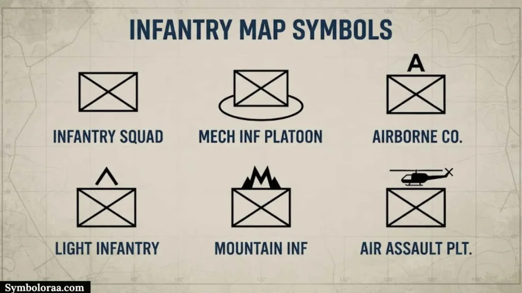
Infantry map symbols represent infantry-related military organizations or elements. They are normally part of a formal symbology system rather than simple soldier illustrations.
The basic infantry representation can be combined with information about the organization and other characteristics. This means that identifying an infantry symbol involves looking at the complete graphic.
When examining infantry map symbols, check:
- The outer frame
- The main icon
- Organizational information
- Modifiers
- Amplifiers
- Labels
- Map position
It is also important to distinguish an official military symbol from decorative graphics. A helmet, soldier, rifle, or similar picture may communicate an infantry theme, but it is not automatically an official military map symbol.
For historical maps, use the original legend whenever possible because infantry representations have changed between periods and military systems.
Military Symbols And Their Meanings
Military symbols can communicate information about units, equipment, command structures, support functions, facilities, activities, and geographic control measures.
Some broad categories are shown below:
| Category | General Meaning |
| Infantry | Infantry-related organization or element |
| Armor | Armored organization or element |
| Artillery | Artillery-related organization or function |
| Engineer | Engineering-related organization or function |
| Reconnaissance | Reconnaissance-related element |
| Headquarters | Command or headquarters element |
| Medical | Medical-related function or facility |
| Logistics | Supply and support function |
| Aviation | Aviation-related element |
| Control Measure | Line, area, route, or other map graphic |
These descriptions are category-level explanations. They should not replace the official key for a particular map.
One reason military symbology can seem complicated is that the meaning is often built in layers. A basic symbol can communicate a category, while additional markings provide more information.
This allows a map to present detailed information without filling the page with long text labels.
Tactical Military Map Symbols
The phrase tactical military map symbols can refer to symbols used to display information at the tactical level. These symbols are especially useful when several organizations, geographic features, and control measures must appear on the same map.
A reader can approach a tactical map in layers:
- Identify the overall symbol type.
- Determine the main category.
- Examine the frame and icon.
- Look for modifiers.
- Read labels and numbers.
- Check nearby lines and areas.
- Confirm the result with the map key.
This approach is useful because tactical symbols often work as a system. A symbol’s position relative to another symbol may be just as important as its internal graphic.
For beginners, learning broad categories first is usually easier than trying to memorize every individual symbol.
Military Map Symbols Key
A second military map symbols key search may come from readers looking for a quick reference chart rather than a general explanation of map legends.
A useful reference can organize symbols by purpose:
Units: infantry, armor, artillery, reconnaissance, and other organizational categories.
Command: headquarters and command-related elements.
Support: medical, logistics, maintenance, transportation, and other support functions.
Equipment: symbols associated with equipment categories.
Control Measures: boundaries, routes, areas, objectives, and other graphical measures.
When using a reference chart, check whether it identifies the military standard and publication date. A chart without a source can be difficult to verify, particularly when it mixes symbols from different countries or historical periods.
The safest practice is to use a quick-reference chart for orientation and the original standard or legend for final identification.
Military Map Symbols Army
Army military map symbols represent information associated with army organizations and land-force activities. The exact system varies according to the country and publication.
For the U.S. Army, FM 1-02.2, Military Symbols, is the current Army reference identified by the Army’s doctrine and terminology resources. The Army’s Joint and Multinational Doctrine Division manages the Army Terminology and Symbology program and lists FM 1-02.2 among its responsibilities.
Army military map symbols can represent:
- Units
- Command elements
- Equipment
- Installations
- Activities
- Support organizations
- Control measures
The term “army military map symbols” is therefore broad. To find a specific symbol, it is helpful to add the country, military period, or standard to the search.
US Military Map Symbols
U.S. military map symbols are documented through U.S. military publications and are used to represent military information in maps, planning products, diagrams, and other visual displays.
The current U.S. Army FM 1-02.2 publication includes military symbol fundamentals and explains concepts such as modifiers, amplifiers, frames, and standard identity colors.
A U.S. military symbol can contain more information than its central icon. The complete construction may include:
- Frame
- Main function
- Modifiers
- Amplifiers
- Labels
- Identity information
The U.S. Army also provides educational material explaining military symbology and references FM 1-02.2 for further study.
When working with older U.S. military maps, however, always consider the date. Historical symbology should be interpreted using references appropriate to that period.
Russian Military Map Symbols
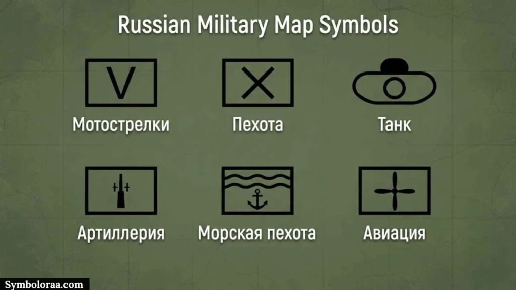
Russian military map symbols are associated with Russian military cartography and can differ from NATO and U.S. conventions.
The first step in identifying a Russian symbol is to determine whether the source is modern Russian or belongs to an earlier Soviet period. Language, abbreviations, map date, and legend can provide important clues.
Useful details to record include:
- Original language
- Publication date
- Map scale
- Geographic region
- Military context
- Legend
- Abbreviations
- Symbol design
A Russian symbol should not automatically be interpreted using a NATO reference simply because it looks familiar. Similar visual shapes can occur in different systems while representing different information.
Historical researchers should preserve the original terminology and consult references from the appropriate period whenever possible.
Army Military Map Symbols
Army military map symbols cover a broad collection of graphics used to represent land-force information. They can include symbols for organizations, equipment, command elements, support functions, and operational graphics.
A useful way to understand a complex symbol is to separate its information into layers:
Category → Function → Organization → Modifier → Context
This method helps explain why two symbols may look almost identical but still communicate different information.
For example, the main icon may establish the broad function, while additional markings identify organizational or capability information. The map position can then provide geographic context.
This is also why copying a symbol from an unrelated chart can lead to mistakes. The same visual element should always be interpreted within its applicable standard.
Infantry Tactical Military Map Symbols
Infantry tactical military map symbols are used when infantry information needs to be shown within a tactical map or diagram.
A complete infantry symbol may contain more information than the central infantry representation. Readers should examine the entire symbol before trying to identify it.
| Feature | What To Check |
| Frame | Overall symbol structure |
| Icon | Main function or category |
| Modifier | Additional information |
| Amplifier | Extra descriptive information |
| Label | Identification |
| Position | Relationship to the map |
This layered approach makes tactical infantry symbology easier to study. It also reduces the chance of confusing a basic symbol with a complete organizational representation.
NATO Military Map Symbols Legend
A NATO military map symbols legend provides the reference needed to interpret NATO-style graphics correctly.
APP-06 describes NATO military symbols as a standardized, structured set of graphical symbols and explains the use of common building blocks for constructing symbol sets. It applies to electronic and manual applications, including mapping and related design work.
When using a NATO legend, examine:
- Symbol frame
- Main icon
- Modifiers
- Amplifiers
- Labels
- Color conventions
- Control-measure graphics
NATO symbology is designed to support a common visual language, but the specific publication or edition still matters. A historical document may use a different version from a current digital implementation.
For that reason, the legend associated with the actual map remains the best starting point.
How To Read Military Map Symbols
Learning how to read military map symbols becomes easier when you treat them as a structured visual language.
Start With The Map Legend
First locate the key or legend. This tells you which symbol system the map is using.
Identify The Main Symbol
Look at the overall frame and central icon. Determine the broad category before studying smaller details.
Check Modifiers And Amplifiers
Additional markings may provide information that is not visible in the main icon. U.S. Army FM 1-02.2 specifically describes modifiers and amplifiers as components that can add information to military symbols.
Read Labels And Numbers
Letters and numbers can provide additional identification. Do not ignore text simply because the map is primarily graphical.
Study The Surrounding Map
Nearby symbols, lines, areas, and geographic features can provide important context.
Confirm The Date And Standard
A symbol from a historical Soviet map should not automatically be interpreted using a modern NATO or U.S. reference.
This six-step approach is useful for students, researchers, historians, and anyone learning military cartography.
Military Map Symbols Generator
People searching for a military map symbols generator may want a convenient way to create graphics for PowerPoint, classroom material, historical diagrams, or map-based illustrations.
A useful generator should clearly identify which symbology system it supports. Before using a generated symbol, check:
- Standard: Does the tool identify its source?
- Version: Is the symbol based on a current or historical system?
- Components: Can it create frames, modifiers, and amplifiers?
- Output: Can the symbol be exported clearly?
- Accuracy: Can the result be compared with an authoritative reference?
For simple educational material, a generator can make diagram creation easier. For formal or historical work, verification is more important than convenience.
A generator should therefore be considered a design aid, not a substitute for the official military map symbols key.
Historical Military Map Symbols
Historical military map symbols are valuable for understanding how military cartography developed. Symbols used during different wars and periods can vary considerably.
When researching a historical map, record:
- Country
- Military organization
- Year or period
- Original language
- Map scale
- Publisher
- Legend
- Geographic location
The date is particularly important. A symbol may have changed meaning or appearance over time.
Historical symbols can also be affected by map scale. A detailed tactical map may use more specific representations than a broad regional map.
If you are reproducing a historical document, keeping the original symbols can preserve the character and accuracy of the source. If you modernize the graphics, clearly identify them as modern interpretations.
Military Map Symbols PowerPoint
Military map symbols can be useful in PowerPoint presentations about military history, geography, cartography, map reading, or standardized symbology.
A simple educational slide can use this structure:
Symbol → Name → Meaning → Map Example → Source
Keep symbols large enough to recognize and avoid placing too many graphics on one slide. A crowded slide can make even a standardized symbol difficult to understand.
For historical presentations, label modern recreations clearly. This helps viewers distinguish an original historical symbol from a modern representation.
PowerPoint can also be used to create a simple military map symbols chart. Each slide or section can focus on one category, such as infantry, armor, artillery, headquarters, or control measures.
Soviet Military Map Symbols
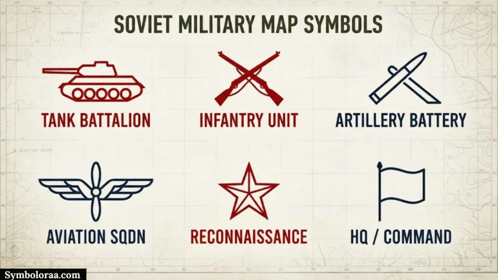
Soviet military map symbols belong to the military cartographic traditions of the former Soviet Union. They are particularly relevant to historical research involving Soviet maps, Cold War documents, military geography, and archival material.
Soviet symbols should be studied separately from modern Russian military symbols because they belong to different historical contexts.
When identifying a Soviet symbol, check:
- The map’s publication date.
- The original language.
- The legend.
- The map scale.
- The geographic area.
- The historical military context.
Soviet abbreviations can also be important. A translation may explain a word without fully explaining the graphical convention used on the map.
For this reason, historical Soviet military map symbols are best interpreted from period-specific references rather than modern symbol charts.
Tactical Military Map Symbols + +
The search phrase tactical military map symbols + + generally suggests that a reader wants additional examples, expanded references, or a larger collection of tactical symbols.
For broader study, tactical military symbology can be organized into several groups:
- Unit Symbols — represent military organizations or elements.
- Equipment Symbols — represent equipment categories.
- Command Symbols — identify headquarters and command elements.
- Support Symbols — represent support functions.
- Control Measures — show boundaries, routes, areas, and other map graphics.
- Activity Symbols — represent activities or conditions defined by the applicable standard.
The plus signs in this search phrase are not an official category of military symbology. They should be understood as part of a search query rather than as a formal symbol classification.
For anyone building a complete reference, organizing symbols by country, standard, category, and historical period is much more useful than putting every symbol into one unsorted list.
FAQ
What are military map symbols?
Military map symbols are graphical signs used to represent military units, equipment, activities, locations, boundaries, and other information on maps. Their exact meaning depends on the applicable standard and context.
How do you read military map symbols?
Start with the map’s legend, identify the main symbol, examine its frame and icon, check modifiers and labels, and then consider the surrounding map context and publication date.
What is the difference between NATO and US military map symbols?
NATO and U.S. military symbology use related standardized concepts, but they should not automatically be treated as identical in every document. The relevant standard and edition should be checked.
Are Soviet and Russian military map symbols the same?
No. Soviet and modern Russian military mapping belong to different historical periods and may use different conventions. The original map date and legend are important for accurate identification.
Can I use military map symbols in PowerPoint?
Yes. Military map symbols can be used for educational presentations, military history, cartography, geography, and map-reading diagrams. For accuracy, identify the standard or source used.
Conclusion
Military map symbols provide a compact visual system for representing units, equipment, activities, command elements, support functions, and geographic information. Their meaning often comes from several components working together, including frames, icons, modifiers, amplifiers, labels, and map context.
NATO APP-06 provides a standardized framework for NATO military symbology, while the U.S. Army’s FM 1-02.2 provides a current reference for Army military symbols. Historical Soviet and Russian systems require additional attention to date, language, source, and original legends.
The best way to learn military map symbols is to begin with the legend and then study symbols by category. Whether you are researching tactical symbols, infantry markings, NATO graphics, U.S. Army symbols, or historical maps, using the correct standard and context will make identification much more reliable.

I’m Madison Reed, a contemporary American author who writes about love, family, friendship, and second chances. I’m fascinated by the choices that shape our lives and the moments that change us forever. My goal is to create honest, emotional stories with characters readers can connect with long after finishing each book.
Three Books:
When We Find Our Way
The Things We Never Said
Summer in September
 Jackson Miller
 Ethan Brooks